The Meteorological and Geophysical Bureau (SMG) said in a statement yesterday that frequent showers and thunderstorms are expected to continue over the coming days despite the weakening of Tropical Storm Maysak, while is also forecast “very hot” weather to affect Macau later this week as Super Typhoon Bavi could impact southern China.
The statement said that Maysak was the first tropical cyclone to affect Macau this year, prompting the issuance of the Stand-by Signal No. 1 and Strong Wind Signal No. 3 as it moved within 800 kilometres of the city before making landfall and weakening over the Chinese mainland.
During the storm’s passage, its outer rainbands brought periods of heavy rain, thunderstorms and strong winds to Macau, with wind speeds reaching Force 6 and higher gusts recorded in several areas, the local weather station said, pointing out that it has issued multiple heavy rain and thunderstorm warnings over the past few days.
Although Maysak has weakened after making landfall, the local observatory said its remaining cloud bands and an associated trough continue to affect the southern China coast. As a result, frequent showers and thunderstorms, accompanied by occasional gusty winds, were expected to persist over the next few days, yesterday’s statement noted.
The observatory urged residents to closely monitor the latest weather information and official warnings before making travel plans, highlighting the development of Super Typhoon Bavi over the western North Pacific since last week.
While the likelihood of Bavi directly affecting Macau remains low, its broad circulation is expected to move towards the Taiwan region, with its outer subsidence* bringing hotter weather to southern China later this week, the statement said.
The observatory forecast daytime temperatures in Macau to reach at least 33 degrees Celsius, with the apparent temperature climbing to extreme levels. The intense daytime heat may also trigger convective activity, increasing the likelihood of brief afternoon showers and thunderstorms.
The statement urged residents to take precautions against heat-related illnesses by staying hydrated and avoiding prolonged outdoor activities during the hottest part of the day, while continuing to pay close attention to the latest weather updates and warning signals through the bureau’s official information channels.
* Subsidence is the downward movement or sinking of a large mass of air in the atmosphere. When a tropical cyclone or typhoon (like Bavi) forms, huge amounts of warm, moist air rush upward near its centre to create massive storm clouds. What goes up must come down. That rising air eventually spreads out at the top of the storm and sinks back down around the outer edges. This outer edge is the outer subsidence zone. – Gemini
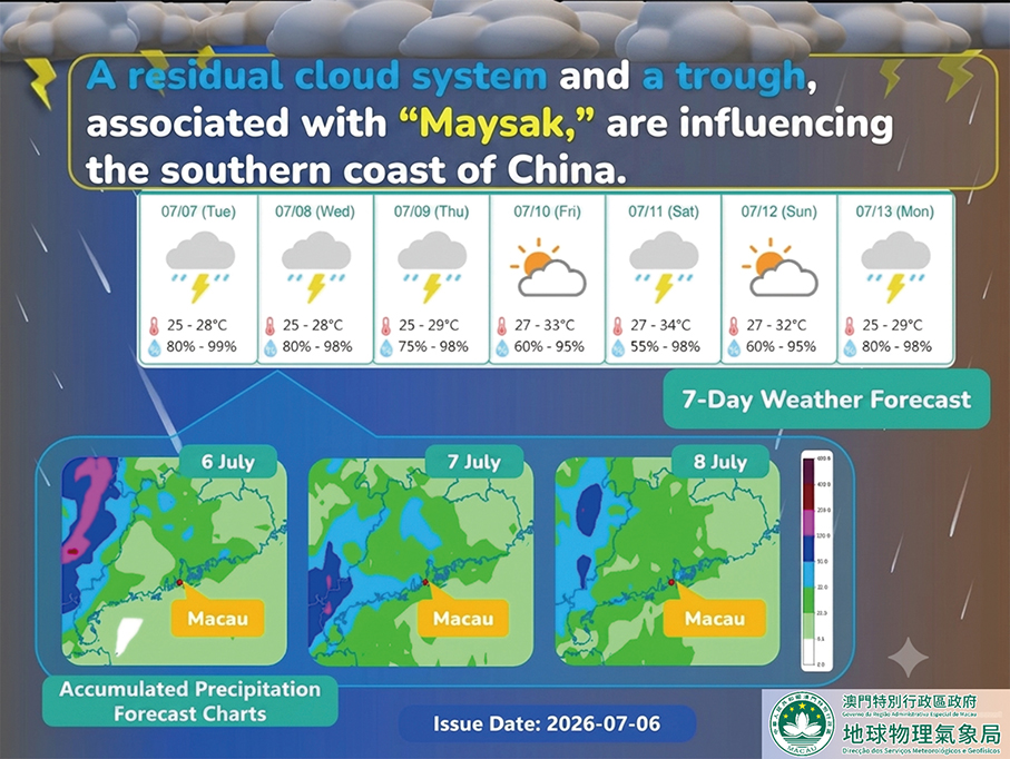
This infographic provided by the Meteorological and Geophysical Bureau (SMG) yesterday shows its accumulated precipitation forecast charts and 7-day forecast. The translation of the image was arranged by the Post.