A trough of low pressure in the South China Sea has become active and could develop into a tropical depression or tropical storm, potentially affecting weather conditions in Macau later this week, according to a statement by the Meteorological and Geophysical Bureau (SMG) yesterday.
The broad trough was gradually consolidating over the central and northern parts of the South China Sea, the statement said, noting that both conventional numerical models and artificial intelligence (AI) models indicate the possibility of a low-pressure area or tropical storm developing within the trough and moving towards the coast of Guangdong later this week.
However, major forecasting models continue to show differences in the system’s potential intensity and track, with uncertainty remaining over its development, the SMG statement said, adding that the bureau is closely monitoring the situation.
Regardless of whether the low-pressure system develops into a tropical storm, its associated circulation is expected to bring a significant increase in wind strength in Macau in the middle and latter parts of this week, along with more frequent showers, the statement noted.
The public is advised to closely monitor the latest weather changes and the bureau’s weather alerts, the statement noted.
Meanwhile, the observatory has also launched the new “Macau Weather” mobile application (Experimental Version) to provide faster weather information and warnings amid the rapid changes and uncertainties associated with tropical systems, the statement pointed out.
Residents can follow the SMG’s official website, official WeChat account and the new “Macau Weather” app for the latest weather information and warning signals, and plan their travel accordingly.
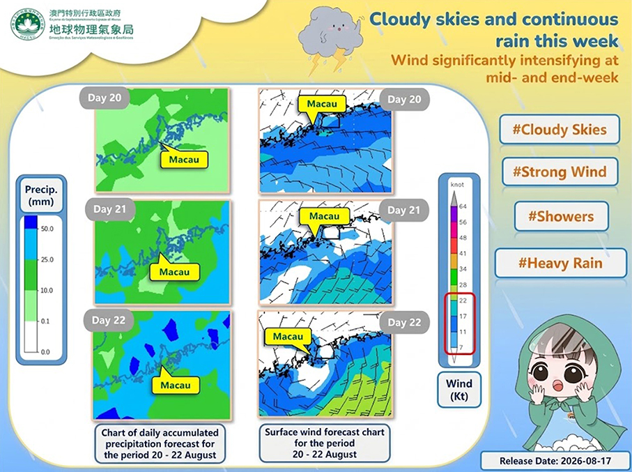
This poster provided by the Meteorological and Geophysical Bureau (SMG) yesterday shows its accumulated precipitation forecast charts and surface wind field for August 20-22; translation from Portuguese arranged by the Post.