Macau has experienced several days of intense heat under the influence of Tropical Cyclone “Dolphin,” with maximum temperatures averaging 37°C at urban stations and reaching 38.3°C at the Outer Harbour station, according to a statement released yesterday by the Meteorological and Geophysical Bureau (SMG).
The bureau attributed the prolonged sunny and extremely hot weather to the continued subsidence associated with Dolphin’s outer circulation, which prompted the issuance of the Orange Hot Weather Alert for several consecutive days.
The Orange alert signifies “extremely hot” weather and is typically issued by the local observatory when maximum temperatures are forecast to exceed 34°C or 35°C. The Yellow alert denotes “very hot” conditions and is activated when temperatures are expected to reach or exceed 33°C in certain areas.
According to the SMG statement, the Taipa observatory recorded a maximum temperature of 35.9°C for two consecutive days – the highest reading at that station so far this year. Overnight, the minimum temperature only dropped to 29.6°C, marking the sixth most intense “hot night” recorded in Macau since records began in 1952.
A trough of low pressure is expected to affect the coast of southern China towards the end of the week, bringing increased showers and thunderstorms to Macau from today through Sunday, the observatory forecast. While this unsettled weather should help ease the oppressive heat, it urged the public to remain vigilant and monitor the latest weather advisories, as summer conditions can shift rapidly between intense heat and heavy rain.
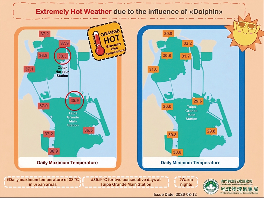
This infographic provided by the local observatory yesterday shows the highest and lowest daily temperatures recorded during the period in which the Orange alert was in force in the past few days.