Macau’s Meteorological and Geophysical Bureau (SMG) forecast in a statement this afternoon that Tropical Cyclone “Ragasa”, located in the northwest Pacific Ocean, will continue moving in a north-northwesterly direction over the coming days, with its intensity expected to increase significantly, possibly reaching the intensity of a super typhoon.
Based on the current forecast track, the observatory said Ragasa was expected to enter the northern South China Sea early next week. “Given its anticipated broad circulation and the combined influence of a northeast monsoon, winds in Macau are expected to strengthen significantly from late Tuesday next week.”
The statement also said that Ragasa was expected to closely approach the Pearl River Estuary next Wednesday, potentially passing within 100 kilometres of Macau. “Winds may reach Force 9 to 11 or above, accompanied by frequent heavy showers and thunderstorms". The bureau noted that "significant storm surge will also occur,” adding that if this coincides with an astronomical high tide, storm surge flooding comparable to that experienced during the catastrophic typhoons Hato (August 2017) and Mangkhut (September 2018) may occur.
According to official records, Hato was the strongest typhoon to affect Macau in 53 years, resulting in 10 deaths, at least 200 injuries, and an economic loss of 12.55 billion patacas (US$1.57 billion).
“As uncertainty remains regarding Ragasa's trajectory and moving speed, members of the public are advised to closely monitor the latest weather information issued by the bureau,” the statement said, adding: “Please take early precautions against wind damage and flooding, and prepare essential emergency supplies.”
The American Meteorological Society defines a typhoon as a tropical cyclone that develops between 180° and 100°E in the Eastern Hemisphere and which produces sustained hurricane-force winds of at least 130 km/h (81 mph).
According to the classification of tropical cyclones by the Hong Kong Observatory, a super typhoon has winds of at least 100 knots (120 mph; 190 km/h).
According to the Beaufort wind force scale, Force 9 indicates wind speed of 77-88 km/h, while Force 11 indicates wind speed of 103-117 km/h.
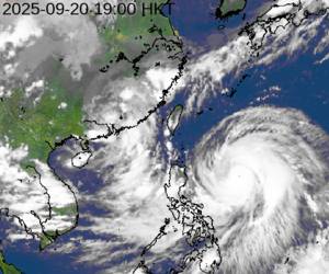
Satellite Imagery courtesy of Hong Kong Observatory